About SeaWi Marine
A full Navigation Tool for Android Tablets and Phones and the best Navigation aid Tool for Sailors. Navigation Data Visualize navigation data on your phone or tablet: position, SOG, COG, speed, heading, apparent wind,...
A full Navigation Tool for Android Tablets and Phones and the best Navigation aid Tool for Sailors.
Navigation Data
Visualize navigation data on your phone or tablet: position, SOG, COG, speed, heading, apparent wind, true wind, ground wind, VMG, Beaufort force, depth, water temperature, UTC time. (A NMEA 2000® or a NMEA 0183 WiFi adaptor is required to receive NMEA data. SeaWi decodes NMEA 2000® and NMEA 0183 data received in TPC, UDP Unicast and Multicast packets).
You can also use the built-in GPS of your device to show position, SOG, COG and UTC time.
AIS Targets
SeaWi decodes AIS information and allows you to visualize AIS target information on your phone or tablet: AIS target name and MMSI, AIS target position, AIS target SOG, AIS target COG, distance and bearing from your vessel, heading, rate of turn, length, beam, draft, IMO, Callsign. SeaWi shows AIS targets on the chart and triggers alarms for dangerous AIS targets or AIS target lost. (An AIS receiver and a NMEA 2000® or a 38400 baud NMEA 0183 WiFi adaptor; or a WiFi AIS receiver is required to receive AIS info).
You can select your buddies and keep track of them.
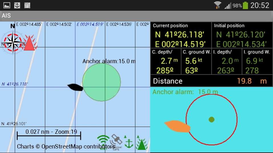
Alarms
SeaWi allows you to program multiple alarms: anchor alarms, depth alarms (shallow water alarm, deep water alarm), alarm of lost data (depth data lost, heading data lost, position data lost, apparent wind data lost) and AIS alarms (dangerous AIS target, lost AIS target).
Tracks
You can create a track tapping the Create new track button from the Track View. The tracks are saved and may be visualized at any time.
You may configure the time period or the distance between track point creation and the number of viewed points at high resolution.
You may continue a saved track whenever you need it.
Waypoints
You can create a waypoint tapping and holding on a chart position. Once the waypoint dialog appears you can modify the waypoint position and place the waypoint at your vessel’s position or at a position of your choosing. You can mark the waypoint with six different symbols: generic waypoint, anchorage waypoint, diving waypoint, fishing waypoint, dangerous waypoint and MOB waypoint. You may add a photo to your preferred waypoints.
Man Over Board (MOB)
You can create a Man Over Board waypoint with only one click (menu MOB). Your vessel's position and UTC time and date will be automatically saved. You can manage the MOB mark as a waypoint from waypoints view.
SMS Service
The SMS Service allows you to receive SMS messages when an alarm is activated. If you are anchored and you are not on board you can program alarms (anchor alarm, depth alarm, dangerous AIS target alarm or lost data alarm) and receive them on your phone. When not on board you can schedule SMS messages at certain intervals of time and receive navigational data from your vessel on your phone.
SeaWi NMEA forwarding
You can forward all navigation and AIS data where you need them. Forward NMEA data to other tablets and phones on your boat. Forward NMEA data remotely and use SeaWi app to visualize the same navigational and AIS data as if you where aboard.
Log Trip and Simulation Mode
You can record navigational data of your trip and recover them later to review your trip in Simulation Mode.
Charts
Off-line OpenSeaMaps charts of the entire world are available. Currently charts of Europe, North America, Mediterranean Sea, Black Sea, Caribbean, Australia, New Zealand, Pacific and North Africa are available. Charts of the rest of the world will be available soon.
OpenSeaMap is an open source, worldwide project to create a free nautical chart. In 2009, OpenSeaMap came into life. This map includes beacons, buoys and other navigation aids. OpenSeaMap is a subproject of OpenStreetMap and uses its database.
Previous Versions
Here you can find the changelog of SeaWi Marine since it was posted on our website on 2016-09-29 01:34:44.
The latest version is 1.09 and it was updated on 2024-04-22 12:45:22. See below the changes in each version.
SeaWi Marine version 1.09.HI21.467
Updated At: 2021-09-21
Changes: - Alarm notification issue solved
- Support for Android 10 and new SeaWi Directory tree
- Due to Google restrictions, this version does not support SMS messages (a full functional version can be downloaded from www.SeaWiMarine.net/downloads/)
- Support for $PCDIN (Version 1.7) NMEA2000 to NMEA0183 conversion (Beta)
- Support for $MXPGN NMEA2000 to NMEA0183 conversion (Beta)
- ip port can be lower than 1024
SeaWi Marine version 1.09.GJ14.466
Updated At: 2020-10-14
Changes: - Support for Android 10 and new SeaWi Directory tree
- Due to Google restrictions, this version does not support SMS messages (a full functional version can be downloaded from www.SeaWiMarine.net/downloads/)
- Support for $PCDIN (Version 1.7) NMEA2000 to NMEA0183 conversion (Beta)
- Support for $MXPGN NMEA2000 to NMEA0183 conversion (Beta)
- ip port can be lower than 1024
SeaWi Marine version 1.09.GI09.465
Updated At: 2020-09-09
Changes: - Support for Android 10
- Due to Google restrictions, this version does not support SMS messages (a full functional version can be downloaded from www.SeaWiMarine.net/downloads/)
- Support for $PCDIN (Version 1.7) NMEA2000 to NMEA0183 conversion (Beta)
- Support for $MXPGN NMEA2000 to NMEA0183 conversion (Beta)
- ip port can be lower than 1024
SeaWi Marine version 1.09.FD24.461
Updated At: 2019-04-24
Changes: - Due to Google restrictions, this version does not support SMS messages (a full functional version can be downloaded from www.SeaWiMarine.net/downloads/)
- Support for $PCDIN (Version 1.7) NMEA2000 to NMEA0183 conversion (Beta)
- Support for $MXPGN NMEA2000 to NMEA0183 conversion (Beta)
- ip port can be lower than 1024
SeaWi Marine version 1.08.CI22.449
Updated At: 2016-09-22
Changes: - Upgrade to Android 6,- Load waypoint list from file and store waypoint list to file,- Error decoding engine oil pressure corrected,- Error on Android 5.0 and higher when downloading list of charts corrected,- Keep screen on configuration,- SeaWi Ruler: distance and course,- NMEA 2000 engines,- One or two engine configuration,- Configurable gauges,- Wind alarms,- AIS targets' closest point of approach (CPA) vector, distance, time and alarms,- AIS targets' COG vector
Disclaimer
Official Google Play Link
We do not host SeaWi Marine on our servers. We did not scan it for viruses, adware, spyware or other type of malware. This app is hosted by Google and passed their terms and conditions to be listed there. We recommend caution when installing it.
The Google Play link for SeaWi Marine is provided to you by apps112.com without any warranties, representations or guarantees of any kind, so access it at your own risk.
If you have questions regarding this particular app contact the publisher directly. For questions about the functionalities of apps112.com contact us.